Capitol Reef
Capitol Reef National Park, located outside Torrey, Utah, was given it's name by Mormons and miners. New to the area in the late 1800's, Mormon settlers believed the white sandstone cliffs looked like the United States Capitol building. Miners, who were previously seafarers, were reminded of a reef when they saw the cliffs reminded them of a reef.
(Don't hold me to this story, it was what we were told and it's a better version than if you google it).
Anyways, we stayed in Torrey in an incredible house with a view. It has a beautiful kitchen that was fully stocked and a back porch with a lovely view of the night sky. Apparently, the best time to view to the night sky is at 3 am. While this option was heavily considered, it was not acted upon because 3 am.


 The previous photos, including the one above, are taken from different resting spots along the trail. I had to stop every 50 yards or so to take a breather.
One thing I learned from this hike: I am not in shape! It didn't take long for me to get back in the gym after returning home.
 Cairns are trail markers and extremely helpful for a hiker on a path that isn't well marked with signs. Cairns guided us through many hikes in Utah and we had to ask how to pronounce it. Quite honestly, I'm still not sure how to correctly pronounce it.

 Kate displaying the view from the top.
 I love the different hues of red, orange, and yellow you see throughout Capitol Reef.
 Stephen, Beth, Kate, Kathryn, Randy, Carrie.
We were the only ones on the trail, so I had to learn how to use the self-timer.

 Stephen and Beth found a great spot to hand their water bottles. I constantly had to check for mine because I would leave it places.


We drove around after finishing the Hickman Bridge hike because it was too hot to not be in air conditioning. We had ambitions of going on the Chimney Rock Loop Trail after dinner to watch the sun set, but we were too exhausted to attempt a 3.5 mile loop. We stayed home to watch
the Warriors win Game 1 instead.
(Don't hold me to this story, it was what we were told and it's a better version than if you google it).
Anyways, we stayed in Torrey in an incredible house with a view. It has a beautiful kitchen that was fully stocked and a back porch with a lovely view of the night sky. Apparently, the best time to view to the night sky is at 3 am. While this option was heavily considered, it was not acted upon because 3 am.

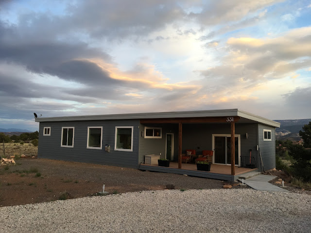
Mom took this picture of our house in Torrey. It was one of our favorite places that we stayed on the trip.
We only spent one full day in Capitol Reef, but it was exhausting!

The graduate wanted a picture of her atop the sign. KT tape and all. Her knee is on the mend now, thanks to surgery and PT, but she used KT tape throughout the trip. We took some of our most strenuous hikes in Utah.

The view of Capitol Reef driving into the park. We were amazed at the diversity of the park, which you will hopefully see in the photos.

Dad taking in the views.

Fruita was a farming community that relied on the Fremont River for irrigation. Known for its orchards, which stand today. During certain times of the year, you are able to pick in some orchards. Cherries were available when we were in Capitol Reef; however, only a few pounds were picked each day.
 Our first hike began after some apple and mixed berry pies from the Gifford House. It was a steep 2 mile hike, roundtrip. It started next to the river, then goes up the edge of a cliff to a mesa top for a beautiful view.


One thing I learned from this hike: I am not in shape! It didn't take long for me to get back in the gym after returning home.


We were the only ones on the trail, so I had to learn how to use the self-timer.


After the Fremont River hike, we had a picnic lunch in the shade. We should have quit while we were ahead, but we decided to try Hickman Bridge after lunch. It was hot, which made the hike somewhat miserable.

I don't remember taking this picture, but I remember opening the file on my computer thinking, "Wow! Where was that? That is pretty cool!". Apparently, this is one of the views on the way to Hickman Bridge. The cliffs on this hike have subtle yellow and orange tints. It was easier to see why the Mormons thought of the white of the Capitol building in DC.

Hickman Bridge ft. the Sun

I think this is the particular structure that reminded the Mormons of the Capitol building. Don't quote me on that.


These cactus flowers bloomed yellow, orange, pink, and red. Beautiful color amidst a brownish ground.
We drove around after finishing the Hickman Bridge hike because it was too hot to not be in air conditioning. We had ambitions of going on the Chimney Rock Loop Trail after dinner to watch the sun set, but we were too exhausted to attempt a 3.5 mile loop. We stayed home to watch

Comments
Post a Comment